
April 29, 2026 by Laurie Fickman, University of Houston
Collected at: https://phys.org/news/2026-04-ai-decades-hidden.html
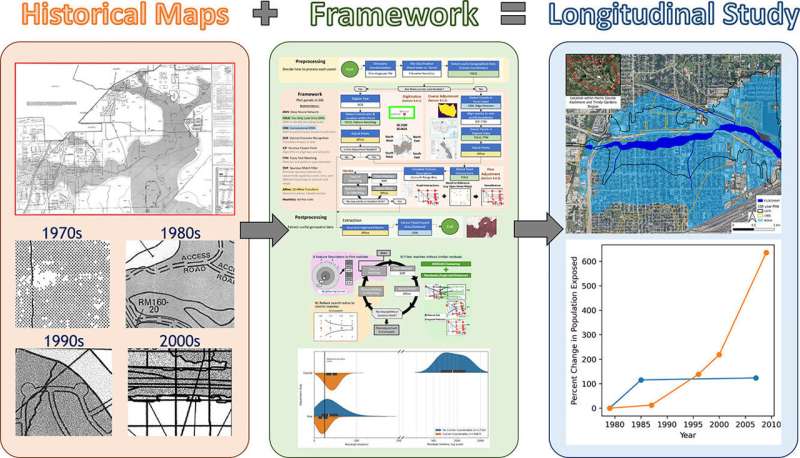
Engineers at the University of Houston have unlocked decades of hidden flood risk data, using artificial intelligence to transform paper flood maps into digital tools that reveal how flooding has evolved—and where future risks are rising. The team developed an AI-driven framework that extracts and georeferences historical Flood Insurance Rate Maps (FIRMs), converting paper records into high-accuracy digital datasets.
The approach allows researchers, planners and policymakers to track how flood risk has shifted over time and make more informed decisions about development, infrastructure and disaster preparedness.
“The resulting dataset of longitudinal flood evolution can now be used to understand how geophysical drivers exacerbated flooding,” said Francisco Haces-Garcia, former UH doctoral student and lead author of the paper published in the Journal of Hydrology: Regional Studies.
“When combined with other variables (e.g., population growth data, critical lifeline services), it would be possible to envision strategies to reduce vulnerabilities and enhance recoveries from floods.”
How flood risk is changing across Houston
With Houston among the most flood-prone metro areas in the United States, the ability to analyze long-term flood trends offers a powerful new tool for understanding risk in a rapidly growing region.
Using data from the 1970s through 2025, the team tested its system with three case studies on sites within the Houston area: Meyerland, Fifth Ward/Kashmere Gardens, and Cypress (near Bridgeland). They found that flood risk varies significantly across locations—highlighting the value of the newly unlocked data.
Together, the case studies reveal a region where flood risk is not uniform—and in some areas, still growing.
- Meyerland (Brays Bayou): Despite major flood control investments, the 100-year floodplain has expanded significantly—likely driven by rapid urbanization and increased impervious surfaces that accelerate runoff.
- Fifth Ward and Kashmere Gardens (Hunting Bayou): Flood risk has also expanded, with changes tied to a mix of drainage modifications, evolving mapping methods, and increased rainfall and development.
- Cypress (Cypress Creek near Bridgeland): In contrast, some areas show reduced floodplain extent, likely due to newer regulations and improved drainage—though nearby studies indicate flood risk remains complex, influenced by factors like land subsidence.
More information
Francisco Haces-Garcia et al, The longitudinal assessment of flood hazard in cities: Unlocking the floodplain record of Houston, TX, USA, Journal of Hydrology: Regional Studies (2026). DOI: 10.1016/j.ejrh.2026.103113
Leave a Reply