April 20, 2026 by University of Southern California
Collected at: https://phys.org/news/2026-04-ai-accurately-wildfires-real.html
USC researchers are developing a computational model that combines satellite data and physics-based simulations to forecast a wildfire’s path, intensity, and growth rate. If you’ve ever been evacuated from your home during a wildfire, you’ll be aware of the terrifying unpredictability of the situation. From your location on the ground—rapidly gathering a few vital belongings and attempting to identify the best route to safety—there’s no way of knowing how fast a fire is growing or which direction it’s likely to take.
That was the experience of Assad Oberai, Hughes Professor of aerospace and mechanical engineering at the USC Viterbi School of Engineering. He was evacuated from his home during the Eaton Fire in January 2025—one of the most destructive wildfires in Southern California history, burning for 24 days before full containment and leaving more than 9,400 structures destroyed and over 1,000 damaged.
“Due to changing climate, we’re seeing more of these extremely intense fires—those that burn very fast and very bright,” he reflected. “We have the data at our fingertips. It all comes down to how we put it to use.”
An initial breakthrough
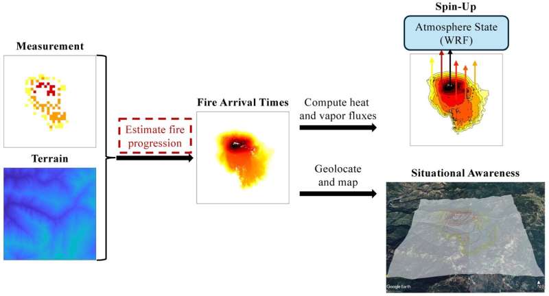
For Oberai, who leads the Computation and Data Driven Discovery (CD3) group at the USC Viterbi Department of Aerospace & Mechanical Engineering, the unpredictability of wildfires posed a computational problem long before becoming part of his lived experience. Back in July 2024, in collaboration with members of CD3 and researchers from multiple universities, Oberai published a paper presenting a model that uses generative AI to combine satellite data and physics-based simulations to forecast a wildfire’s path, intensity, and growth rate.
The paper was recognized as an important breakthrough in understanding and predicting wildfires. However, Oberai and co-author Bryan Shaddy, a doctoral student and member of CD3, were keenly aware that there were still a few missing pieces of the puzzle.
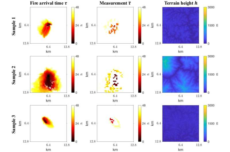
Training data samples, with target fire arrival time solutions 𝝉 in the first column, measurements ¯ 𝝉 in the second column, and terrain height 𝒉 in the third column. Credit: Remote Sensing (2026). DOI: 10.3390/rs18020227
Advancing the model
The original system relied on data from VIIRS, a polar-orbiting satellite that detects heat signatures with relatively high spatial resolution (within a few hundred meters) but revisits the same location only twice a day. The result is precise but intermittent information; a sequence of snapshots separated by long intervals in which the fire continues to evolve.
Now, a new paper published in the journal Remote Sensing presents an advancement of the model. The goal is to reduce uncertainty about where and when a fire started, crucial information for predicting its spread.
“We’re still using data from VIIRS, but now we’re bringing in observations from a geostationary satellite, GOES, to obtain a more accurate measurement of the ignition time,” Oberai said. “That addition, and the fact that the new model accounts for terrain, means that it makes better informed and therefore, more accurate predictions.”
GOES continuously observes the same region and updates every five minutes. Although the geostationary satellite does not offer the same spatial detail as VIIRS, it provides something the earlier model lacked: a reliable estimate of when a fire ignited. That information reduces a significant source of uncertainty. A fire detected at a given moment can reflect very different histories depending on when it began. That early window is where prediction is most difficult—and most consequential.
The power of prediction
“If you know how a fire has initially spread, you can make a more accurate prediction of where it’s going to go next,” Oberai said. “Ignition time is key to that understanding. If I’m aware that the fire started 10 hours ago, I gain a sense of its pace of growth. If the fire has covered the same amount of ground in two hours, I know that it’s spreading rapidly and that will prompt me to make different decisions.”
A further refinement of the model factors in the conditions of the terrain, accounting for how slope and elevation influence the direction and speed of the spread of the fire. For example, it is well recognized that fire tends to spread faster upwards on a slope. The new model accounts for these types of effects. It is also trained on simulations of real wildfires rather than generic scenarios, capturing the variability of weather, vegetation, and topography that governs how fires actually behave.
Taken together, these changes allow the model to reconstruct fire progression with greater accuracy. This is demonstrated by the close alignment of the reconstructions with high-resolution infrared perimeters measured by aircraft—what used to be a process of watching, waiting, and basing actions on observations is now a process of real-time prediction. In short, it’s all about staying one step ahead of the fire.
Can computation beat the clock?
“When it comes to effectively fighting a fire, this tool has the power to provide real-time estimates and a type of aerial view of what the fire looks like at any given instant,” said Oberai.
For Shaddy, who grew up in the California Central Valley where summers are associated with wildfire smoke, and Oberai, who now has a strategy for evacuating his home at short notice, that concept of the aerial view—the bigger picture, the informed perspective—is a source of equanimity.
That said, they know that they’re working to a tight timeline as they continually refine their wildfire prediction model. Fire seasons in the western United States are predicted to be longer and more severe, and the goal is to make these tools available to first responders and wildfire management planners. For now, it’s a race against the clock to convert data into next-generation models that will provide actionable insights for those on the front lines.
More information
Bryan Shaddy et al, Generative Algorithms for Wildfire Progression Reconstruction from Multi-Modal Satellite Active Fire Measurements and Terrain Height, Remote Sensing (2026). DOI: 10.3390/rs18020227
Leave a Reply