February 2, 2026 by Rômulo Marques-Carvalho and Elton Vicente Escobar-Silva
Collected at: https://phys.org/news/2026-02-subjectivity-landslide-susceptibility.html
In recent years, numerous landslides on hillsides in urban and rural areas have underscored that understanding and predicting these phenomena is more than an academic curiosity—it is a human necessity. When unstable slopes give way after intense rainfall, the consequences can be devastating, with both human and material losses. These recurring tragedies led us to a simple yet powerful question: Can we build landslide susceptibility maps that are more objective, transparent, and useful for local authorities and residents?
The answer led us to compare two susceptibility analysis methods: the traditional Analytical Hierarchy Process (AHP) and its statistical version, the Gaussian AHP. After months of multidisciplinary work, we found that the Gaussian AHP, which relies on data rather than subjective judgments, better identifies critical areas in a more balanced manner and is consistent with the landslide patterns observed in the field. We share here our journey and the lessons we learned. Our findings are published in Scientific Reports.
Why compare traditional AHP with Gaussian AHP?
Traditional AHP is a decision-support technique widely used in geosciences and urban planning. It relies on pairwise comparisons of factors such as slope, soil type, and distance to rivers or roads to assign relative weights based on expert opinion. One advantage is that it allows the incorporation of accumulated experience; a disadvantage is the subjectivity and the effort required when many factors are involved. In our case, we worked with 16 physical and environmental variables that influence slope instability—from terrain morphometry to land cover and proximity to rivers.
The Gaussian AHP starts with the same factors but eliminates the subjective judgment step. Instead of manually comparing each variable, we calculated the mean and standard deviation of the distribution of values for each data layer and used these statistics to derive a Gaussian factor. Variables with greater spatial variability (e.g., geomorphology and proximity to rivers) automatically receive higher weight, reflecting intrinsic patterns in the data. This approach makes the method easily replicable and less susceptible to personal bias, and allows the integration of large volumes of geospatial data.
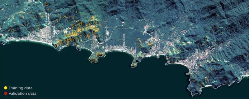
Building the susceptibility maps in São Sebastião
We chose the municipality of São Sebastião, on the north coast of São Paulo, Brazil, as a case study because official surveys indicate it is among the most vulnerable cities in the country. There, mountainous relief, escarpments, and urban occupation of slopes create a high-risk context. We selected 16 conditioning variables (e.g., slope, relative slope position, terrain ruggedness, soil type, and distance to rivers and roads) and collected high-resolution data from satellites, digital terrain models, and landslide inventories.
When applying the traditional AHP, we convened specialists from environmental management, geography, and urban planning to define the relative importance of each variable. The process generated 120 pairwise comparisons, resulting in a weight matrix in which slope received the highest weight (18.2%), followed by relative slope position, Terrain Ruggedness Index, and geomorphology. The susceptibility map generated showed a distribution similar to that reported in other studies, with 23.5% of the area classified as very high susceptibility.
In the Gaussian AHP, we processed each data layer using a statistical approach, normalizing the values and calculating the mean and standard deviation for each variable. This allowed us to determine the Gaussian weight for each variable based on its spatial variability. Notably, the most important factors changed: Geomorphology moved to first place, followed by distance to rivers and distance to roads, while slope fell to sixth position. The resulting map showed that 26.3% of the area was classified as a very high susceptibility class, with a significant increase in areas near rivers and roads.
Lessons learned
Our comparison of the two methods revealed three clear lessons:
- Less guesswork, more confidence—The Gaussian AHP relies on the numbers hidden in the data rather than experts’ opinions. By letting the data determine which factors matter most, the resulting maps are more consistent and easier for emergency responders to trust when deciding where to focus their efforts.
- Location matters more than we thought—Being close to rivers and roads turned out to be more important than we imagined. Rivers funnel the water that triggers landslides, and roads cut into hillsides and weaken them. The data-driven method addressed this by giving these factors greater weight, underscoring that where you are can greatly influence your occurrence.
- No model can capture everything—Our approach doesn’t yet account for every detail. It can miss factors that don’t vary much from place to place, and it doesn’t include human actions such as building retaining walls or improving drainage. To improve, we’ll need to add real-time weather and soil-moisture data and pair our technique with more sophisticated computer models that learn over time.
Why does this matter to you?
If you live in a mountainous region, work in urban management, or simply care about extreme events, understanding how we build susceptibility maps can save lives. The landslides in São Sebastião showed that the combination of intense rainfall (accumulations of up to 683 mm in 24 hours) and disorderly occupation creates a perfect storm. Using more objective methods, such as the Gaussian AHP, we can provide civil defense and urban planners with a more precise tool for identifying critical areas and guiding evacuations, drainage projects, and land-use policies.
We also learned that science needs to engage with society. It is not enough to publish a technical paper; we need to explain concepts like AHP and statistical variability in an accessible manner. We hope that our experience will inspire other researchers to consider simple, replicable tools that public managers can use, including in municipalities with limited technological resources.
This story is part of Science X Dialog, where researchers can report findings from their published research articles. Visit this page for information about Science X Dialog and how to participate.
Publication details
Rômulo Marques-Carvalho et al, Comparative analysis of traditional and Gaussian Analytical Hierarchy Process (AHP) methods for landslide susceptibility assessment, Scientific Reports (2025). DOI: 10.1038/s41598-025-22136-6
Journal information: Scientific Reports
Leave a Reply