Jack Loughran Fri 3 Jan 2025
Collected at: https://eandt.theiet.org/2025/01/03/lidar-equipped-robot-creates-detailed-3d-models-assess-dangerous-areas-disaster-zones
A lidar-equipped robot that can create detailed 3D models of its surroundings has been developed by researchers who believe it could be used to assess areas deemed too dangerous for humans.
In disaster zones following a chemical plant incident or flooding, emergency services need ways to quickly get an overview of the situation. But in many cases, they are not permitted to enter the scene itself in order to avoid putting themselves at risk.
Lidar, which stands for Light Detection and Ranging, is a remote-sensing technology that uses laser pulses to create 3D models of its surroundings.
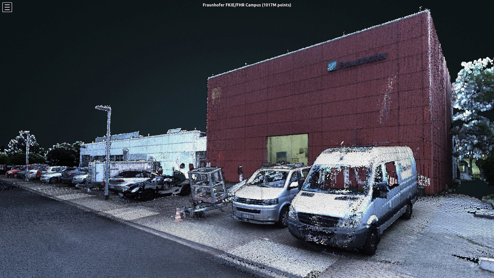
The new robot, developed by a team at German research institution Fraunhofer, uses lidar to produce geometrically accurate 3D environments that are then coloured in using camera images.
The end result is a virtual 3D environment that combines a vivid representation of the potential danger zone with precise geometric information. Remote users can then move around freely in the virtual scenery.

Fraunhofer
Timo Röhling, the team’s technical project manager, said: “Compared to robot systems that use cameras to explore a danger zone, our project goes a big step farther. The laser pulses supply measurements for precision 3D cartography of an area of terrain or building. Distances and dimensions are not estimated but instead determined with accuracy down to just a few centimetres.”
The lidar laser is attached to a rotating turntable and scans an area of 16 vertical sections, or ‘slices’, per second. In total, the device emits 1.3 million laser pulses per second, which are used to produce a 3D point cloud of the environment.
The raw data acquired is pre-processed by a computer module inside the robot before it even finishes its mission. The final visualisation is then produced on a stationary basis during post-processing. It takes about three hours to map an area measuring 400×400 metres. In a disaster when time is of the essence, accelerated operation can be used to get an initial overview in as little as one hour. It is also possible to explore an area using multiple vehicles simultaneously.
“You might think of us melding the camera images and point cloud together. This gives us a vivid, detailed and also geometrically accurate 3D environment showing buildings, open space and objects,” Röhling added.
The robot system is generally radio-controlled by a user working with a joystick and tablet. If there is no radio contact, the robot systems could also move around the terrain autonomously.
The team designed the system to be as versatile as possible – the laser module and turntable can be mounted on a wide range of different vehicles. Depending on the terrain, vehicles with wheels or tracks or even drones could be used. Users assemble the specific components to fit each scenario.
Leave a Reply