January 26, 2026 by Regional Service for Agri-Food Research and Development
Collected at: https://phys.org/news/2026-01-remote-enables-early-vole-outbreaks.html
Researchers at the Regional Service for Agri-Food Research and Development (SERIDA) have developed a new large-scale remote sensing model that will enable comprehensive, high-resolution monitoring of fossorial water vole populations in areas where they cause agricultural damage. The system combines data collected in the field with satellite-derived information, facilitating detailed and continuous control of the appearance and spread of these rodents across extensive agricultural areas.
This work has been published in the journal Scientific Reports under the title “Large-scale remote sensing model enables an integrated monitoring approach for high-resolution tracking of pest vole populations.” The study was led by researchers from the Regional Service for Agri-Food Research and Development (SERIDA), Aitor Somoano and Ana del Cerro, in collaboration with technicians from the company Spectralgeo (Logroño), the regional government of Galicia (Xunta de Galicia), and Tragsatec.
Researcher Aitor Somoano explains that “the fossorial water vole is a rodent considered harmful, which can become a highly significant agricultural pest when its populations undergo demographic outbreaks.” According to him, voles cause severe damage to pastures and crops, generate substantial economic losses, and may pose a risk to public health, as they are capable of acting as reservoirs for certain diseases.
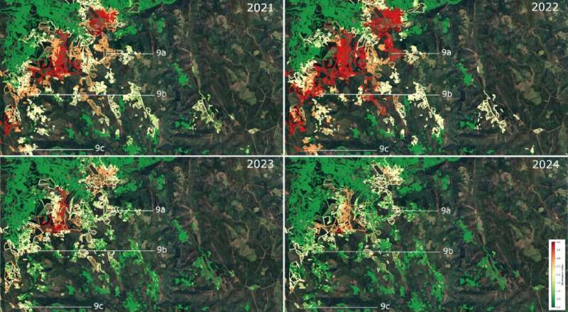
Thanks to this innovative approach, SERIDA researchers have succeeded in developing a predictive habitat model that identifies, with high accuracy (97%), the areas where the species is present or could potentially expand, as well as an Optimized Damage Index capable of estimating vole abundance based on the level of damage observed in vegetation, taking climatic variability into account. In addition, the model determines the most suitable times of the year to carry out monitoring of vole populations.
These tools make it possible to identify in advance those areas where there is a higher probability of a population outbreak of these voles, even without the need for continuous field sampling.
Thanks to this system, more timely and efficient management of this harmful species can be implemented, and farmers and livestock producers can be warned so that they adopt control measures before damage becomes significant. The tool can also be useful for public administrations in planning early warning systems and in resource management. In addition, this new model offers numerous advantages:
- It reduces the need for field surveys, which require time, specialized personnel, and high costs.
- It enables periodic monitoring of large agricultural areas through the use of satellite imagery.
- It facilitates early detection of areas at risk of population outbreaks.
- It helps support better-informed decisions to prioritize control resources.
- It can be applied to other rodent species and to regions with similar conditions, promoting the use of remote sensing in integrated pest management.
Methodology
This study was carried out in an agricultural area of approximately 1,285 km² in northwestern Spain, in the Ancares region (Galicia), characterized by a heterogeneous landscape. In this area, between 2021 and 2024, two annual field surveys (in spring and autumn) were conducted with the aim of estimating vole populations based on signs of vole activity recorded in the selected plots. The survey covered 23,834 plots, which together comprised 8,058 hectares affected by this species. In total, 16,768 abundance estimates were carried out.
Data from the Sentinel-2 satellite were also collected, featuring fine spatial resolution (10 m) and high temporal revisit frequency, which made it possible to analyze vegetation health and to derive spectral indices related to damage caused by these voles.
Finally, a modeling phase was carried out, applying machine-learning techniques to develop predictors of both potential habitat and vegetation damage attributable to fossorial water voles.
Publication details
Aitor Somoano et al, Large-scale remote sensing model enables an integrated monitoring approach for high-resolution tracking pest vole populations, Scientific Reports (2025). DOI: 10.1038/s41598-025-25091-4
Journal information: Scientific Reports
Leave a Reply